
Nepal Glacier Collapse Kills at Least 359 and Leaves Over 1,300 Missing

On this page
By the Machu Picchu News editorial team · August 28, 2026
What We Know Right Now
At least 359 people have been confirmed dead and more than 1,300 remain missing across Nepal and China’s Tibet region, after a Himalayan glacier collapse sent a wall of water, mud and rock through border towns and valleys. Rescue teams are searching for survivors in terrain that is hard to access at the best of times.
The disaster unfolded on August 26, 2026, when a massive flash flood stormed down river valleys in Nepal. The glacier collapse triggered a landslide and the resulting flood wiped away villages downstream.
Of the more than 1,300 people still unaccounted for, 476 are foreign tourists, according to Nepal’s National Disaster Risk Reduction and Management Authority.
How the Catastrophe Unfolded
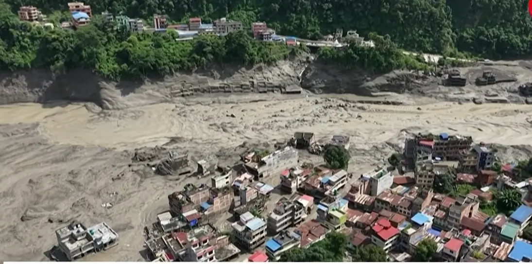
At approximately 8:40 AM local time on Wednesday, August 26, a large section of glacier broke away high above the Lhende river in Tibet. The falling ice and rock dammed the river and, shortly afterwards, when the blockage gave way, the surge tore through settlements in Nepal’s Rasuwa district, destroying homes, hydropower plants and border infrastructure.
Video geolocated by CNN captured where a large portion of the glacier near the Langtang Lirung peak broke along the Nepal-China border, causing a devastating avalanche and landslide. A photographer who witnessed the event wrote that he heard the sound of the falling glacier around 10:30 AM local time, and at first mistook it for a military exercise.
Initial assessments based on seismic and satellite data, as well as videos of the event, indicate that a very large section of a glacier detached and collapsed after the bedrock below it gave way.
Earthquake or Glacier? The Answer Surprised Scientists
Early reports attributed the collapse to a magnitude 4.4 earthquake. However, the United States Geological Survey later confirmed that the seismic signal was caused by the landslide itself, not by an earthquake. The landslide packed enough force to register as a magnitude 5.2 seismic event remarkable for a non-tectonic event.
Flood waters reached heights described as «outrageously high» possibly 40 to 50 meters and may have moved at speeds of up to 70 kilometers per hour (44 miles per hour).
The Destruction on the Ground
At least 19 bridges and approximately 40 kilometers (25 miles) of road have been destroyed, further hampering the search for survivors. Nepal Police spokesperson Abi Narayan Kafle said the death toll is expected to rise further as rescue teams reach more remote areas.
A second landslide occurred approximately three hours after the first, raising serious concerns that the initial collapse left surrounding slopes unstable and that further events could follow.
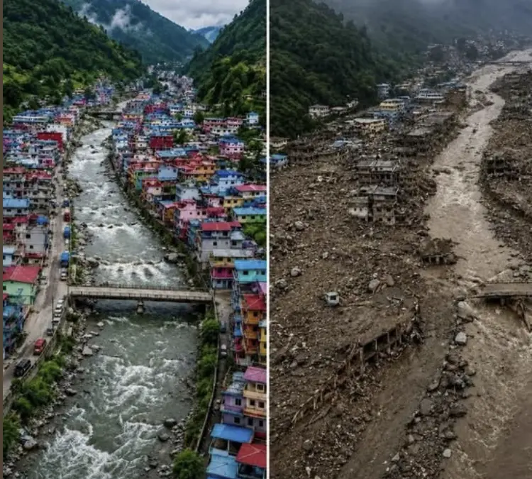
Satellite imagery captured by Planet Labs before and after the flood shows how buildings and roads have been completely washed away. Scientists established from comparing these images that an enormous chunk of glacier sheared off from high on a mountain the visible scale of the destruction is extraordinary.
What Scientists Are Saying
«What we’ve certainly confirmed there was a large ice avalanche, probably a mixture of ice and rock, which detached and then became fluid and then transformed into this devastating flood,» said Simon Allen, a research associate at the University of Zurich who studies glacial hazards in the Himalayas.
Allen added that early analysis of satellite images and field photos indicates the bedrock beneath the glacier failed. The mountains have been shrouded in clouds, meaning the precise chain of events will likely be better understood once satellites allow a clearer examination of the source area.
Scientists at the Nepal-based International Centre for Integrated Mountain Development are working to confirm a preliminary assessment that a large volume of ice and rock debris entered the Lende Khola, a tributary of the Bhotekoshi River, causing it to overflow its banks with catastrophic force.
Climate Change as an Underlying Factor
Scientists have said that climate change likely helped trigger this glacier collapse. Nepal is one of the world’s most vulnerable countries to global warming. The Himalayas hold the largest concentration of glaciers outside the polar regions, and their accelerating melt over recent decades has significantly increased the risk of events like this one, a pattern scientists have been warning about for years.
Nepal: A Nation at the Frontline of Himalayan Risk
Nepal, sometimes searched online as Nepal’s, Nepals, or with typographical variations, is a landlocked nation in the heart of the Himalayas, bordered by India and China. It is known worldwide as home to Mount Everest and eight of the fourteen peaks above 8,000 meters.
With a geography dominated by mountains exceeding 5,000 meters, Nepal is one of the world’s most exposed countries to glacier and water-related natural disasters:
- Glacial Lake Outburst Floods (GLOFs): Nepal has recorded dozens of these events in recent decades, as warming temperatures cause glacial lakes to overflow their natural dams
- Monsoon landslides between June and September, heavy rains destabilize slopes already weakened by glacial melt
- Avalanches the Nepali Himalayas are among the highest-risk avalanche zones in the world
- Earthquakes Nepal sits in a highly seismically active zone; the 2015 earthquake killed nearly 9,000 people
The August 26 disaster follows a pattern of increasing glacial hazard events across Nepal in recent years, including the Tilgau glacial lake outburst in May 2025 and the Rasuwagadhi flood in July 2025 both in the same general region now devastated by the glacier collapse.
The Impact on Tourism in Nepal
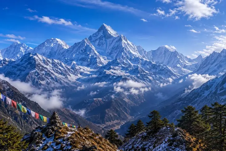
Nepal receives millions of visitors every year, drawn by trekking in the Himalayas, attempts on Everest and other 8,000-meter peaks, the cultural heritage of Kathmandu’s temples and palaces, and the landscapes of the Annapurna and Langtang regions.
The fact that 476 of the missing are foreign tourists reflects how many international visitors were in the area when the disaster struck. Trekking routes in the Rasuwa district including approaches to Langtang National Park, one of Nepal’s most visited trekking destinations pass directly through the affected zone.
Anyone with family members or friends in the affected area can contact:
- The Nepal Embassy or consulate in their home country
- Nepal’s National Disaster Risk Reduction and Management Authority: ndrrma.gov.np
- Nepal Police emergency line: 100
- Their country’s foreign affairs emergency hotline
What the Satellite Images Show
Satellite imagery provided by Planet Labs shows the glacier near the Nepal-China border on August 25 one day before the collapse and then again after the disaster, revealing the scale of what was lost. Scientists comparing these before-and-after images confirmed that an enormous section of glacier sheared away from high on the mountain, triggering everything that followed downstream.
The images also show the destruction to infrastructure in the valleys below: roads, bridges, and settlements that simply no longer exist.
Timeline of the Disaster
| Time (Nepal local time) | Event |
| 8:37 AM — August 26 | Glacier collapse above the Lhende river, Tibet. Seismic signal equivalent to magnitude 5.2 recorded |
| ~8:40 AM | Falling ice and rock dam the Lhende river |
| Morning | The blockage gives way; wall of water, mud and rock tears through Rasuwa district, Nepal |
| ~11:30 AM | Second landslide occurs in the affected area |
| August 26–27 | Rescue teams deployed; communications and roads cut off |
| August 27 | USGS confirms the seismic signal was caused by the landslide, not a pre-existing earthquake |
| August 28 | At least 359 confirmed dead; over 1,300 missing, including 476 foreign tourists |
Travel Advice for Visitors to Nepal
If you are currently in Nepal or planning to visit in the near future:
- Check official travel advisories from your government’s foreign affairs department before proceeding with any Himalayan trekking itinerary.
- Avoid Rasuwa district and the Tibet border areas until further notice.
- Register your trip with your country’s consulate or embassy before trekking in remote Himalayan areas.
- Always purchase travel insurance that includes high-altitude emergency evacuation coverage this disaster demonstrates how real and unpredictable the risks are.
- Follow official updates from Nepal’s Disaster Management Authority at ndrrma.gov.np for real-time information.
Frequently Asked Questions
What happened in Nepal on August 26, 2026?
A glacier on the Nepal-Tibet border collapsed, triggering an ice and rock avalanche that dammed and then released the Lhende river, sending a catastrophic wall of water through Nepal’s Rasuwa district. As of August 28, 2026, at least 359 people are confirmed dead and over 1,300 remain missing.
What caused the glacier collapse in Nepal?
Scientists determined that the bedrock beneath the glacier failed, causing a massive section of ice and rock to break away. The event generated seismic waves equivalent to a 5.2 magnitude earthquake. Climate change and the accelerating melt of Himalayan glaciers are identified as underlying contributing factors.
How many tourists are missing in Nepal?
As of August 28, 2026, 476 of the more than 1,300 missing people are foreign tourists.
Is it safe to travel to Nepal right now?
The affected area is Rasuwa district and the Tibet border zone. The rest of Nepal including Kathmandu, the Annapurna region and Everest Base Camp was not directly affected. Check your government’s travel advisories before planning your visit.
What is the connection between this disaster and climate change?
Himalayan glaciers are melting at an accelerating rate due to global warming. This melt weakens the base of glaciers and increases the risk of collapse events. Nepal is considered one of the world’s most vulnerable countries to climate-related water disasters, and scientists say the frequency and scale of events like this one is expected to increase.
Was this triggered by an earthquake?
No. Initial reports suggested a magnitude 4.4 earthquake, but the U.S. Geological Survey confirmed that the seismic signal was caused by the landslide itself. The glacier collapse was powerful enough to generate seismic waves on its own equivalent to a 5.2 magnitude event.
This article is updated as new information becomes available. Confirmed death and missing figures reflect official data as of August 28, 2026 at 8:00 AM Peru time.


